On Tuesday night, June 2, I will be attending the first Queens Bus Rapid Transit workshop in Jackson Heights. Here’s a proposal I will be bringing with me.
“Bus rapid transit” is no more than the sum of its parts, and many elements of it can be used by themselves to produce a significant improvement in transportation quality. One such element is enclosed stations with pre-boarding fare control. The Union Turnpike station is ideally suited to this, because most of the facilities already exist. The subway station has the usual fare control system with turnstiles and high-wheel gates. It also has an enclosed connection to a roadway.
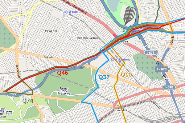
Just north of Kew Gardens, an eight-lane highway passes under Queens Boulevard. The middle four lanes are the Jackie Robinson Parkway headed for East New York. The lanes on either side carry through traffic on Union Turnpike. On either side of those lanes are two more with traffic turning onto Queens Boulevard.

The Union Turnpike-Kew Gardens subway station is a major station in central Queens. It’s one of the several points where subway riders from Manhattan and western Queens can transfer to the bus network that is the only transit for much of eastern Queens. The Q46 goes east on Union Turnpike from here, the Q74 goes north on Main Street, the Q10 goes south to Kennedy Airport and the Q37 south to Ozone Park.

The subway-bus transfers are often slow and clumsy because the buses take circuitous routes to turn around. For example, the Q46 terminates on the north side of Queens Boulevard, then has to go two blocks west, make a U-turn, go back east and then take a big left onto Union Turnpike.
Even to get to the bus stops, subway passengers have to climb three flights of stairs. For some of the more popular buses, the stairs are not wide enough to handle peak demand, and there is conflict between passengers going down and passengers going up.
Meanwhile, people who live in Glendale don’t have any subway or train service, and limited bus service to connect them to the subway. Getting from Kew Gardens Hills to Kew Gardens requires a long walk, a long ride or two bus transfers. These are two of the Underserved Areas identified in the NYC DOT Phase II report (PDF).
Improving these transfers could trim five to ten minutes off of each bus rider’s commute, which would be a huge boost to transit in central Queens. Here’s one way to do it: right now the buses all go up to Queens Boulevard, turn and stop at the subway stairs. Passengers bound for the subway go up to go down. But if the buses continued on through the tunnel they’d be at the mezzanine level of the subway station.
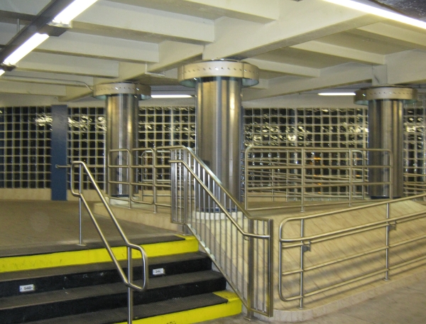
How would the passengers get into the station? Well in fact, that mezzanine used to be open to Union Turnpike for many years, with just a guardrail separating people from cars. It was not very pleasant walking next to the noisy, smelly, speeding traffic. In a recent renovation the MTA installed glass bricks that make the station much nicer; you can see the road through them.

Now imagine that the glass bricks, fence and guardrail are gone, and there are bus stops there. You’re riding in on the Q46, and instead of going up to Queens Boulevard it goes through the tunnel and stops. You get off, go down one flight of stairs, and get on your train. If you’re coming from the train, you go up one flight of stairs and get on your bus. No turnstiles, no dipping Metrocards, no waiting for everyone else to dip their Metrocard, and much less crowding on narrow stairs.
To do this, the MTA would have to reconfigure the routes, which could allow for better connections between neighborhoods. The Q74 and Q46 could turn around at Park Lane, but they could also continue on to Metropolitan Avenue, Woodhaven Boulevard or Myrtle Avenue in Glendale. The Q10 and Q37 could turn at the 141st Street loop, but they could continue along the Grand Central Parkway service road to Main Street, Parsons Boulevard, 164th Street or even Utopia Parkway, connecting with the Q25, Q34, Q44 or Q65.
The roadway under Queens Boulevard would also have to be reconfigured. The approach to the bus stops would have to be restricted to buses only, to prevent private vehicles from beating the fare by dropping off passengers inside the fare control zone. This would also prevent through traffic from being blocked by stopped buses. I don’t know how much space there is under there for bus stops, so it may require devoting all four lanes of what’s currently considered Union Turnpike to buses and requiring cars to use the four middle lanes. However, it might only require one lane in each direction, in which case the barriers could be moved so that all car traffic has three lanes available to it.